Empowering Your Projects with MEFFEL’s Precision Geotechnical Services
WIn today’s fast-paced industrial landscape, the margin for error is slimmer than ever. Whether you’re involved in mining, construction, or large-scale infrastructure projects, making decisions based on guesswork simply isn’t an option. That’s where MEFFEL steps in—providing the specialized knowledge and data-driven insights you need to keep projects on schedule, on budget, and, above all, safe. At the heart of our offerings are three critical services that work together to deliver a holistic picture of site conditions: Geological Mapping, Surface Deformation Alerts, and Stockpile Monitoring.
Understanding the Bigger Picture
Major projects are rarely simple endeavors. From the moment you break ground, you need a thorough grasp of site geology, ongoing ground stability, and resource management. Overlook any one of these areas, and your project could be at risk of delays, budget overruns, or even safety incidents. By combining our three services, MEFFEL provides a complete geotechnical intelligence solution that leaves no aspect overlooked.
Geological Mapping: Building a Solid Foundation
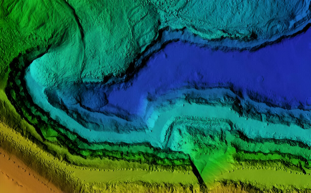
Projects often begin with questions about the land itself: Are there fault lines nearby that could compromise stability? How do different rock layers behave under stress? Where are the richest mineral veins located? Geological mapping answers these questions by detailing the subsurface conditions that could impact your engineering or extraction operations.
At MEFFEL, our geologists go beyond traditional field surveys. We incorporate satellite imagery, drone-based photogrammetry, and various geophysical methods to capture every nuance of your site. This multi-pronged approach yields a far more accurate mapping effort, reducing the potential for surprises during construction or drilling phases.
But it’s not just about the data—it’s about how that data is interpreted and applied. Our in-house experts utilize advanced modeling software to translate raw information into actionable insights. By doing so, we help you identify hidden risks like unstable slopes, overlooked aquifers, or mineral zones that may be more concentrated than initial surveys suggested. Armed with this knowledge, you can design your project to work with the land, rather than against it.
Surface Deformation Alerts: Staying One Step Ahead
Even with a meticulously designed site plan, the ground beneath your feet can shift—sometimes with little to no warning. Natural factors like soil composition, groundwater fluctuations, and seismic activity all contribute to surface deformation. Left unchecked, these changes could result in equipment damage, project delays, or, in worst-case scenarios, threats to worker safety.
MEFFEL’s Surface Deformation Alert system takes a proactive stance. Instead of waiting for visible signs of trouble, we track even the smallest ground movements in near real-time. High-precision sensors, such as GNSS units and inclinometer arrays, deliver continuous streams of data. We also integrate satellite-based technologies like InSAR (Interferometric Synthetic Aperture Radar) to gain a wide-angle perspective on potential deformation across larger areas.
The real power of this service lies in our advanced analytics and early-warning protocols. If measurements deviate beyond predetermined thresholds, the system triggers immediate alerts. This gives you the lead time necessary to investigate the issue and, if needed, implement safety measures or adjust operational plans. It’s a comprehensive safeguard that can prevent minor shifts from escalating into major setbacks—keeping both your team and your investments secure.
Stockpile Monitoring: Maximizing Efficiency, Minimizing Waste
For sectors like mining, construction, and agriculture, managing materials efficiently is crucial. Stockpiles of ore, aggregate, or soil represent not just inventory but also potential profit or loss. Manual measurement methods are often labor-intensive and prone to error. If you underestimate stockpile volumes, you risk running out of materials at a critical moment. Overestimate, and you might tie up capital in unnecessary reserves.
That’s where MEFFEL’s Stockpile Monitoring service delivers a game-changing advantage. Our drone-based and satellite-based survey methods capture detailed topographic information, which then feeds into specialized modeling software. From there, we can calculate exact volumes and monitor changes in these stockpiles over time. The resulting data ensures more efficient supply chain planning, better budgeting, and the ability to swiftly respond to unexpected market demands or project adjustments.
Additionally, this technology-driven monitoring process helps with accountability and compliance. Regulatory agencies often require accurate reporting of material extractions and inventories. By having updated volumetric data readily available, you’ll be able to meet these requirements effortlessly and maintain transparent operations that foster trust among stakeholders.
Why Partner with MEFFEL?
- Deep Expertise: Our team includes seasoned geologists, engineers, and data scientists who have honed their skills on projects around the globe. We blend field experience with rigorous academic training to provide solutions that are both practical and innovative.
- Cutting-Edge Technologies: From drone photogrammetry to satellite-based sensors, we constantly refine our toolset to ensure our data is highly accurate and delivered in the most efficient way possible.
- Holistic Perspective: By offering three core geotechnical services under one roof, we help you maintain a complete overview of your project. This integrated approach can significantly reduce the margin for error and the time spent coordinating multiple contractors.
- Bespoke Solutions: No two sites—or clients—are exactly alike. We customize our methods and reporting to address your unique goals, timelines, and budget constraints.
- Ongoing Support: Our relationship doesn’t end with the delivery of a report. We’re committed to long-term partnerships, offering continuous monitoring, data updates, and personalized consultations as your project evolves.
Bringing It All Together
Geological Mapping ensures you start on stable ground. Surface Deformation Alerts keep you informed about ongoing shifts, so you can respond proactively. Stockpile Monitoring streamlines your resource management for maximum efficiency. Each of these services is valuable on its own—together, they create a robust, end-to-end framework that can drastically elevate the success and security of your operations.
At MEFFEL, we don’t just deliver data; we deliver clarity and confidence. By blending scientific rigor, advanced technologies, and a commitment to client satisfaction, we’ve become a trusted ally for teams looking to balance ambition with sustainability and safety.
Are you ready to power your next project with actionable geotechnical intelligence? Connect with us at MEFFEL, and let’s explore how our suite of services—Geological Mapping, Surface Deformation Alerts, and Stockpile Monitoring—can be tailored to meet your project’s needs. Together, we’ll chart a path to safer, smarter, and more efficient operations.